Access Denied
IMPORTANT! If you’re a store owner, please make sure you have Customer accounts enabled in your Store Admin, as you have customer based locks set up with EasyLockdown app. Enable Customer Accounts

Newsletter
accuracy
ArcGIS
aviation
Bad Elf
base/rover
Compliance
Cost Savings
Custom Integration
data collection
Digital Asset Mapping
Drone
Education
GCP
geospatial
gis
GNSS
GPS
ground control
Ground Penetrating Radar
LiDAR
MARCH2024
MAY2023
Newsletter
NMEA
planes
Rangefinder
Safety
Safety Optimization
SDK
SEPT2023
Categories
- All topics
- 3D modeling
- accessory
- accuracy
- Accurate Survey Data
- AEC
- aerial
- affordable
- Agents of Discovery
- analysis
- Apglos Survey Wizard
- APRIL2024
- ArcGIS
- architecture
- As-built
- AUG2023
- aviation
- awareness
- Bad Elf
- Bad Elf GPS
- base
- base/rover
- Bluetooth
- breaks
- buffer
- Christmas
- community
- Compliance
- Conference
- constellations
- construction
- construction professionals
- consultation
- coordinate systems
- Cost Effective Surveying
- Cost Savings
- Custom GIS Solutions
- Custom Integration
- data collection
- datum
- DEC2023
- Digital Asset Mapping
- Dinosaur fossils
- Drone
- drones
- Education
- Efficient Land Surveys
- enablement
- engineering
- Esri
- Extreme Accuracy
- fatalities
- FEB2024
- Field Maps
- field workers
- Flex
- Flex Mini
- Fossil location
- frequency
- GCP
- GCT
- Geodesy
- geography
- geomatics
- geoprocessing
- geospatial
- Geospatial Data
- Geospatial Enablement Team
- GET
- gis
- GIS Training
- GNSS
- GPS
- GPS data collection
- GPS Integration
- ground control
- ground control targets
- Ground Penetrating Radar
- hazards
- High Precision Survey
- high-accuracy
- injuries
- JAN2024
- jingle bells
- JULY2023
- JUNE2023
- land surveying
- land surveyors
- Laser
- LiDAR
- Mapping
- MARCH2024
- math
- MAY2023
- NAD27
- NAD83
- NATRF2022
- Newsletter
- NMEA
- NOV2023
- oct2023
- Operations Optimization
- Paleontological fieldwork
- Paleontology
- planes
- planning
- portable
- PPE
- Precise Mapping
- prevention
- radio
- Rangefinder
- real-time data collection
- remote data collection
- rover
- RTK
- Safety
- Safety Optimization
- safety tips
- SDK
- SEPT2023
- Sign Management Solution
- signals
- solutions
- song
- Stratigraphy
- support
- survey-grade
- Surveying Technology
- total stations
- training
- Tree Inventory
- Tree Management Solution
- User Friendly Survey App
- utility design
- UTM
- WGS-84
- workplace safety
-

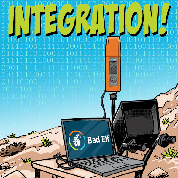
Unlocking the Potential of GNSS Data: Bad Elf’s Symphony of Integrations
 Bad Elf's commitment to custom integrations transcends the realm of mere data exchange. By fostering collaboration and offering a robust SDK, they empower users to unlock the true potential of GNSS technology, transforming data collection from a mundane task into a symphony of scientific exploration.
 -


Water Utilities: Revolutionize Your Municipal Operations
Transform your community's outdated paper maps and inspection practices with Bad Elf GNSS receivers and ArcGIS Online Lead Service Line Inventory solution.
-

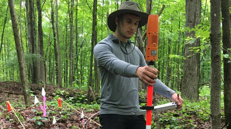
Archaeology made easy with the Bad Elf Flex Base and Rover
The Bad Elf Flex GNSS Base and Rover is an excellent solution for archaeology projects due to its accuracy, price, and versatility. -


How to set ground control for drone operations
Setting ground control points (GCPs) is an essential step for achieving high-accuracy mapping drone flights. -
April 2023 Newsletter - HERE, HERE!
April 2023 Newsletter - HERE, HERE!
- Checklist workflows
- Safety
- Quote Corner
-


Invalid password
Enter
Use left/right arrows to navigate the slideshow or swipe left/right if using a mobile device