
Newsletter
Categories
- All topics
- 3D modeling
- accessory
- accuracy
- Accurate Survey Data
- AEC
- aerial
- affordable
- Agents of Discovery
- analysis
- Apglos Survey Wizard
- APRIL2024
- ArcGIS
- architecture
- As-built
- Asset inventory
- Asset management
- AUG2023
- aviation
- awareness
- Bad Elf
- Bad Elf GPS
- base
- base/rover
- Bluetooth
- breaks
- buffer
- Christmas
- community
- Compliance
- Conference
- constellations
- construction
- construction professionals
- consultation
- coordinate systems
- Cost Effective Surveying
- Cost Savings
- Custom GIS Solutions
- Custom Integration
- data collection
- datum
- DEC2023
- Decision-making
- Digital Asset Mapping
- Dinosaur fossils
- Drone
- drones
- Education
- Efficient Land Surveys
- enablement
- engineering
- Esri
- Esri ArcGIS
- Extreme Accuracy
- Facility management
- fatalities
- FEB2024
- Field Maps
- field workers
- Flex
- Flex Mini
- Fossil location
- frequency
- GCP
- GCT
- Geodesy
- geography
- geomatics
- geoprocessing
- geospatial
- Geospatial Data
- Geospatial Enablement Team
- Geospatial technology
- GET
- gis
- GIS implementation
- GIS solutions
- GIS Training
- GNSS
- GNSS receivers
- GPS
- GPS data collection
- GPS Integration
- ground control
- ground control targets
- Ground Penetrating Radar
- hazards
- High Precision Survey
- high-accuracy
- injuries
- JAN2024
- jingle bells
- JULY2023
- JUNE2023
- land surveying
- land surveyors
- Laser
- LiDAR
- Local government
- Mapping
- MARCH2024
- math
- MAY2023
- MAY2024
- NAD27
- NAD83
- NATRF2022
- Newsletter
- NMEA
- NOV2023
- oct2023
- Operations Optimization
- Paleontological fieldwork
- Paleontology
- planes
- planning
- portable
- PPE
- Precise Mapping
- prevention
- quickcapture
- radio
- Rangefinder
- real-time data collection
- Real-time monitoring
- Regulatory compliance
- remote data collection
- rover
- RTK
- Safety
- Safety Optimization
- safety tips
- SDK
- SEPT2023
- Sign Management Solution
- signals
- Simplified GIS
- Small organizations
- solutions
- song
- Spatial analysis
- Stratigraphy
- support
- survey-grade
- survey123
- Surveying Technology
- total stations
- training
- Training solutions
- Tree Inventory
- Tree Management Solution
- User Friendly Survey App
- utility design
- UTM
- WGS-84
- workplace safety
-


Ditch the Two-Fisted Tango: One-Handed Geospatial Magic with Bad Elf and Your Phone

Bad Elf's Universal Paddle Mount lets your phone and Flex Mini tango in one hand, freeing the other for field freedom and geospatial magic.
-

As-builts: Construction's Crystal Ball (If the Crystal Ball Was Half Drunk)
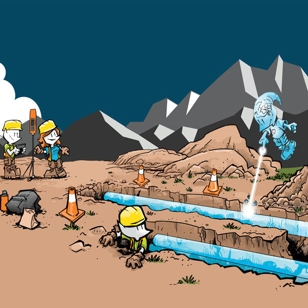
Despite the as-built's aspiration for architectural precision, construction realities often diverge, necessitating high-accuracy spatial data tools like Bad Elf GPS to bridge the gap between blueprint ideals and built environments. -


Lost in Geo-Jargon? Bad Elf's GET to the Rescue!
 Navigating the complexities of the geospatial industries? Let Bad Elf's Geospatial Enablement Team (GET) be your cartographer to success. Our experienced professionals offer comprehensive services to empower your journey, from deciphering terminology to implementing cutting-edge solutions.
 -


Bad Elf Flex Mini, there isn’t anything mini about it except the size!
Ditch bulky baggage and embrace the mighty mini: Bad Elf Flex Mini packs pro-grade geospatial precision into a pocket-sized powerhouse. -

Navigating the Realm of High-Accuracy Engineering Data: A Foundational Guide
Learn the basics about datums, coordinate systems, and projections in this Bad Elf YouTube video. -


The Multi-Frequency GPS Receiver: A Bad Elf's Guide to Unparalleled Precision
In summary, a multi-frequency GPS receiver enhances the accuracy, reliability, and overall performance of GPS-based positioning by simultaneously processing signals from multiple frequency bands, making it well-suited for demanding applications that require high precision and resilience in challenging environments. -

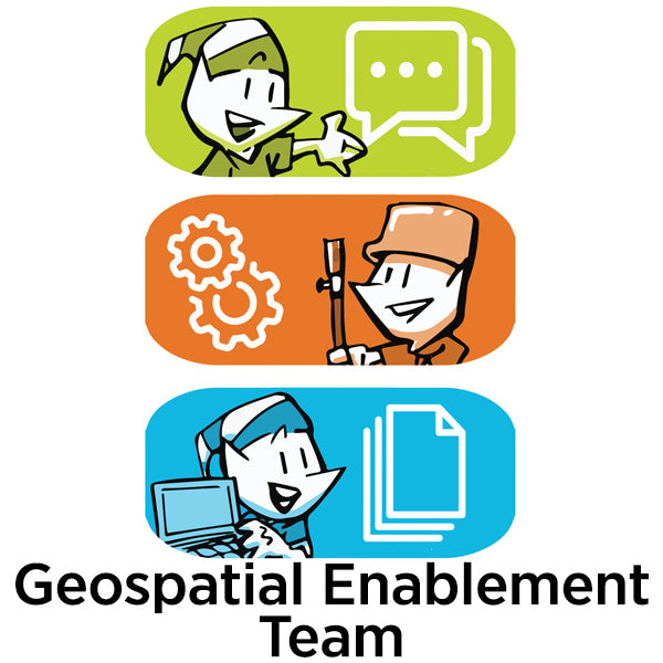
Geospatial Enablement Team (GET)
Bad Elf is the premier geospatial enablement organization. Whether you need immediate support launching a digital, geospatial systems of record or you just need the best low-cost, high-accuracy GPS on the market, Bad Elf is here for you. Contact the Geospatial Enablement Team today.
-

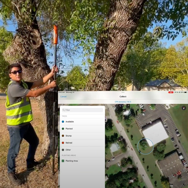
Parks and Recreation: Master Tree Management
Advanced ArcGIS Tree Management solution using the Bad Elf Flex GNSS receiver. Simplify tree inventory, inspections, and maintenance, while providing invaluable insights for informed decision-making -

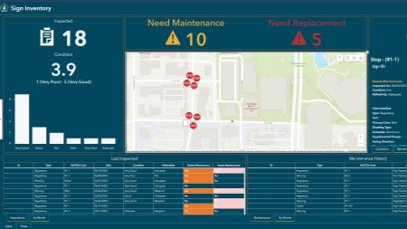
Sign Management for Local Governments
Empower your municipality with the Bad Elf GNSS and the Esri ArcGIS Online Sign Management solution. Say goodbye to paper maps and outdated databases as we transition your workflow to a digital platform with our hardware and training services.
-


Water Utilities: Revolutionize Your Municipal Operations
Transform your community's outdated paper maps and inspection practices with Bad Elf GNSS receivers and ArcGIS Online Lead Service Line Inventory solution.
-


Don't Miss the Epic Bad Elf Booth at the Esri User Conference!
Hey there, fellow geospatial enthusiasts! If you're using Bad Elf GPS and Esri GIS software, we've got something extraordinary in store for you at the Esri Users Conference. Prepare yourself for a unique, funny, and downright awesome experience that you won't find anywhere else. -

Tree Inventory
Tree inventories hold significant importance for organizations, communities, and individuals due to the numerous benefits that trees provide to the environment.


